

Bluelink Ocean Forecasting Partnership Renewed: What It Means for Marine and Coastal Projects
On 6 August 2026 the Australian Government confirmed the formal renewal of the Bluelink Partnership, a tripartite arrangement between CSIRO, the Bureau of Meteorology and the Department of Defence that has underpinned national ocean forecasting since 2001. The renewal secures ongoing funding for hydrodynamic modelling covering local beach conditions, near-shore coastal zones, regional current systems and global ocean circulation, with a stated focus on next-generation predictive capability for sea temperature, salinity, currents and wave dynamics.
For environmental practitioners this is not a peripheral science announcement. Bluelink outputs sit behind the oceanographic inputs used in marine and coastal impact assessments across Australia, including plume dispersion modelling for outfalls, brine discharge design, offshore wind and port feasibility studies, and thermal stress tracking for reef and seagrass ecosystems. A continuity gap or degradation in this data infrastructure would flow directly into the reliability of assessments submitted to Commonwealth and state regulators.
Developers, port authorities, offshore energy proponents, coastal councils and their legal advisers should treat the renewal as confirmation that the baseline oceanographic dataset underpinning many EPBC Act referrals and state marine approvals will continue to be maintained and improved, rather than lapse or be wound back after a 25-year operating history.
Key Details of the Bluelink Renewal and Ocean Forecasting Commitments
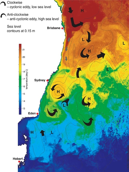
Bluelink has operated continuously since 2001 as a joint CSIRO, BoM and Defence program delivering hydrodynamic and oceanographic forecasting at multiple spatial scales, from individual beaches and near-shore coastal cells through to regional current systems such as the East Australian Current and the broader global ocean circulation. The 6 August 2026 announcement formalises continued government funding for this partnership and commits to advancing forecasting resolution and accuracy for four core parameters: sea temperature, salinity, currents and wave dynamics.
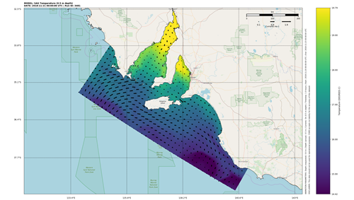
The practical output of Bluelink is high-resolution predictive ocean data that feeds hydrodynamic transport models used to simulate contaminant plumes, sediment dispersion and thermal or saline stratification in coastal and offshore waters. These models are a standard requirement in Environmental Impact Statements for offshore wind farms, seabed cabling and port infrastructure, and in discharge licence applications for desalination brine and industrial trade waste outfalls.
Defence involvement in the partnership reflects the dual-use nature of ocean forecasting, with the same subsurface current and temperature data supporting maritime operational planning as well as civilian environmental and scientific applications. This dual funding base has historically been a key reason Bluelink has maintained continuity of service over multiple government terms, and the renewal extends that arrangement rather than introducing a new model or data platform.
No specific budget figure, contract term length or named upgrade milestones were disclosed in the announcement beyond the commitment to next-generation predictive technologies. Practitioners relying on Bluelink-derived datasets in current or upcoming assessments should monitor CSIRO and BoM technical notes for details on resolution upgrades, model version changes and any transition arrangements as the renewed program is implemented.
How Bluelink Data Supports EPBC Act Referrals and State Marine Approvals
Hydrodynamic and oceanographic data of the kind produced by Bluelink is a direct input to assessments made under Part 3 of the Environment Protection and Biodiversity Conservation Act 1999 (Cth), which governs referrals affecting Commonwealth marine areas, listed threatened marine species and ecological communities of national environmental significance. Ocean current and temperature forecasts inform the ecological risk assessments and hydrodynamic transport modelling that Commonwealth decision makers expect to see in referral documentation for offshore infrastructure and marine works.
At the water quality level, the Australian and New Zealand Guidelines for Fresh and Marine Water Quality (ANZG 2018) rely on physical and chemical stressor thresholds, including temperature and salinity guideline values, to assess whether a discharge or activity will degrade marine water quality. Accurate current and mixing data allows practitioners to define dilution and mixing zones with greater spatial precision, which directly affects whether a proposed outfall or brine discharge can demonstrate compliance with default guideline values.
State frameworks including the Marine Estate Management Act 2014 (NSW), the Coastal Management Act 2016 (NSW), the Marine Parks Act 2004 (Qld) and the Environment Protection Act 2017 (Vic) each require proponents to demonstrate that coastal works or discharges will not degrade sensitive marine habitats or protected marine park zones. Bluelink-derived forecasts are a common technical basis for the current and dispersion modelling submitted to satisfy these state-level requirements, meaning the quality and currency of the underlying dataset has a direct bearing on assessment defensibility in NSW, QLD, VIC and SA jurisdictions alike.
Practical Implications for Proponents, Consultants and Coastal Developers
Proponents preparing EIS documentation or discharge licence applications that depend on hydrodynamic modelling should confirm which version of Bluelink data their consultant has used and whether more recent, higher-resolution outputs are available under the renewed program. Where models rely on older baseline datasets, regulators have in the past required supplementary field verification or applied more conservative assumptions in approval conditions, and this pattern is likely to continue where proponents do not demonstrate use of current oceanographic data.
Site owners and developers involved in offshore wind, port expansion or desalination projects should factor the renewed program into their assessment timelines, as resolution upgrades under the next-generation commitment may prompt regulators to expect updated modelling for long-running applications. Legal advisers reviewing approval conditions tied to ocean monitoring or adaptive management should also check whether those conditions reference Bluelink outputs, and seek clarification from consultants on how model version changes will be documented so that compliance reporting remains consistent over the life of the approval.
References and related sources
- Primary source: www.csiro.au
- nt.gov.au
- antarctica.gov.au
- minterellison.com
- sers.net.au
- ANZG Water Quality Guidelines
- EPBC Act
How iEnvi can help
iEnvi provides specialist consulting services relevant to this topic. Our team includes CEnvP Site Contamination Specialists with experience across contaminated land, groundwater, remediation, ecology, and regulatory compliance.
- iEnvi contaminated land investigation services
- iEnvi remediation and validation services
- iEnvi expert services and independent review services
This is an iEnvi Machete news summary. Prepared by iEnvi to summarise the source article for contaminated land, groundwater, remediation, approvals and site risk professionals.
Published: 11 Aug 2026
Need advice on this topic? Speak to an iEnvi expert at info@ienvi.com.au or 1300 043 684, or contact us online.
Need advice on this issue? iEnvi provides practical, senior-led environmental consulting across contaminated land, remediation, ecology and environmental risk.
Team credentials Ecological risk assessment Contaminated land services Remediation services Talk to iEnvi