

Landgate and DWER win innovation award for the WAVE vegetation extent pilot
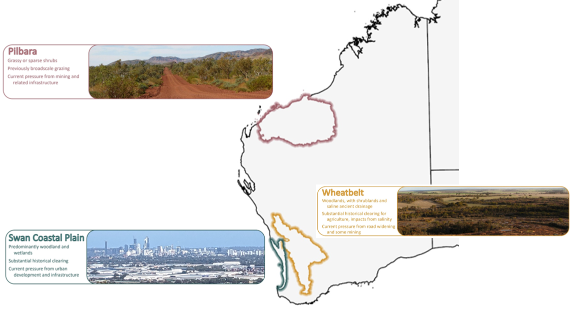
Landgate and the Department of Water and Environmental Regulation (DWER) have won the 2026 WA Government Innovator of the Year Award for the WA Vegetation Extent (WAVE) Project Pilot. WAVE is a deep learning workflow that maps where native vegetation occurs, using satellite imagery and multispectral data. The WA Government announced the award on 4 November 2026. The work concentrated on the Pilbara, where sparse, seasonally dry vegetation is very hard to separate from surrounding soil and rock using conventional satellite mapping.
The government describes the pilot as a flagship initiative under the Western Australian Government’s Native Vegetation Policy, and describes the award winning workflow as offering a viable pathway towards more consistent vegetation extent information for Western Australia. That wording is measured and should be read that way. WAVE is a pilot. It has not been adopted as a regulatory dataset, and the public material does not indicate that its outputs are being used in clearing permit decisions.
For proponents, their consultants and their lawyers, vegetation extent is where any clearing assessment starts. A boundary drawn in the wrong place shapes the area of a permit application, the scale of an offset, the scope of field survey and, sometimes, whether a clearing permit is needed at all. A consistent, repeatable extent dataset shared by applicants and assessing officers would change how those questions are argued. This article covers what WAVE does, what it does not do, and how practitioners should treat it while it remains a pilot.
Why greenness indices struggle with Pilbara vegetation, and what WAVE maps instead
WAVE was built to fix a known weakness in satellite vegetation mapping: heavy reliance on pixel level spectral greenness indices such as the Normalised Difference Vegetation Index (NDVI). NDVI is the difference between near infrared and red reflectance, divided by their sum. Dense, actively photosynthesising vegetation returns high values. Low cover, dry foliage and senescent plants return weak values. In the Pilbara, spinifex hummock grasslands and seasonally dry shrublands can therefore produce NDVI values close to those of bare ground, rock outcrop and lateritic soils. Vegetation that is plainly present in the field can be missed or under mapped.
According to the announcement, Landgate’s Earth Observation team and DWER trained deep learning computer vision models on satellite imagery and multispectral datasets to assess broader landscape context, texture and structural patterns, not individual pixel values in isolation. The principle is that a model reading how features are arranged across the landscape can pick up signals a single pixel cannot carry, such as the spacing of shrubs, the clumping of hummock grasses, or the way vegetation follows drainage lines and breaks of slope. The Pilbara was chosen because it is where conventional greenness based methods fail most consistently.
WAVE maps extent, meaning where native vegetation is present. It does not map condition. Vegetation condition is a separate work stream under the Native Vegetation Policy Implementation Roadmap and sits outside WAVE’s extent mapping. An extent layer will not identify individual species, threatened or priority flora, threatened or priority ecological communities, fauna habitat value or degradation from weeds, grazing or fire. Practitioners should keep that limit in mind whenever the dataset is discussed in an approvals context.
The pilot supports the Implementation Roadmap objective identified as Target 3.1: a statewide native vegetation extent dataset and monitoring system. As a government artificial intelligence project, WAVE also falls within the WA Government Artificial Intelligence Policy and Assurance Framework, which governs how agencies develop and use AI tools. The public material reviewed for this article does not report model accuracy statistics, validation results against field survey, or a timetable for statewide coverage. Those are the details practitioners will need before treating the outputs as more than a screening layer.

How WAVE relates to WA clearing permits under the EP Act
In Western Australia, clearing native vegetation is regulated under Part V, Division 2 of the Environmental Protection Act 1986 (WA). Clearing is an offence unless it is authorised by a clearing permit or covered by an exemption under Schedule 6 of the Act or the Environmental Protection (Clearing of Native Vegetation) Regulations 2004. DWER assesses most clearing permit applications. For mining and petroleum activities, permits are assessed under delegation by the state’s mines and petroleum regulator, now the Department of Mines, Petroleum and Exploration (previously part of the Department of Energy, Mines, Industry Regulation and Safety). Applications are assessed against the ten clearing principles in Schedule 5 of the Act. These cover biodiversity, significant fauna habitat, threatened flora, threatened ecological communities, remnant vegetation in extensively cleared areas, watercourses and wetlands, land degradation, conservation areas, water quality and flooding. Several of these principles depend on knowing how much native vegetation remains in a region, so a reliable statewide extent dataset bears directly on how they are applied.
Larger proposals may also be referred to the WA Environmental Protection Authority under Part IV of the EP Act. In that case, flora and vegetation survey is expected to follow the EPA’s Technical Guidance on Flora and Vegetation Surveys for Environmental Impact Assessment. Where matters of national environmental significance are involved, the Environment Protection and Biodiversity Conservation Act 1999 (Cth) applies as well. None of these frameworks currently treats an automated extent layer as a substitute for field survey. WAVE would sit at the desktop and screening end of the assessment process, not replace the survey effort these instruments require.
How other states use vegetation mapping in clearing regulation
The development has parallels in the eastern states. Queensland regulates clearing under the Vegetation Management Act 1999 using the regulated vegetation management map, which sorts land into categories that determine whether clearing is regulated and which rules apply. The map draws on Queensland Herbarium regional ecosystem mapping, and Queensland separately tracks woody vegetation change through the satellite based Statewide Landcover and Trees Study. Because the map carries legal weight, landholders can apply for a property map of assessable vegetation to correct mapping errors on their land. That mechanism shows what tends to follow once an extent map moves from information to regulation: a formal process to dispute and amend it.
New South Wales takes a similar approach for rural land through the Native Vegetation Regulatory Map under the Local Land Services Act 2013, which works alongside the Biodiversity Conservation Act 2016. In both states, mapping has become a point of contention in individual approvals. If WAVE is eventually scaled up and given a formal role in Western Australia, similar questions about accuracy, update cycles and correction rights are likely to come up.
How practitioners should treat WAVE while it remains a pilot
Until the outputs are released with documented accuracy and validation, WAVE should be treated as background information, not evidence. In practice, that means:
- Continue to scope and carry out flora and vegetation survey in line with the EPA’s Technical Guidance and DWER’s clearing permit requirements. A desktop extent layer does not reduce those obligations.
- Where WAVE outputs become available for a site, compare them with existing mapping and field data and record any differences. Discrepancies in sparse spinifex and shrubland country are worth noting, since that is the vegetation the pilot was designed to capture.
- Do not rely on WAVE outputs to argue that an area has no native vegetation, or to set the area of a clearing permit application or offset, unless DWER confirms the dataset can be used that way.
- Watch for published accuracy statistics, validation against field survey, licensing and release terms, and any statement from DWER on how the dataset will be used in assessments.
The award recognises a promising method for a problem that has frustrated vegetation mapping in arid Western Australia for years. Whether it changes clearing assessment will depend on what the government publishes next about accuracy, coverage and regulatory status.
References and related sources
- Primary source: www.wa.gov.au
- insidestategovernment.com.au
- spatialsource.com.au
- squarespace.com
- www.wa.gov.au
How iEnvi can help
iEnvi provides specialist consulting services relevant to this topic. Our team includes CEnvP Site Contamination Specialists with experience across contaminated land, groundwater, remediation, ecology, and regulatory compliance.
- iEnvi contaminated land investigation services
- iEnvi remediation and validation services
- iEnvi expert services and independent review services
This is an iEnvi Machete news summary. Prepared by iEnvi to summarise the source article for contaminated land, groundwater, remediation, approvals and site risk professionals.
Published: 09 Nov 2026
Need advice on this topic? Speak to an iEnvi expert at info@ienvi.com.au or 1300 043 684, or contact us online.
Need advice on this issue? iEnvi provides practical, senior-led environmental consulting across contaminated land, remediation, ecology and environmental risk.
Team credentials Contaminated land services Remediation services Groundwater services Talk to iEnvi