Overview
A landmark study published on 14 April 2026 in the peer-reviewed journal Nature Water has quantified the accelerating threat of seawater intrusion into coastal aquifers worldwide, with southern Australia explicitly identified as a high-risk hotspot. The research was conducted by an international team including scientists from the Climate Service Center Germany (GERICS) in Hamburg and the Institute of Geography at Johannes Gutenberg University Mainz (JGU). By assembling and analysing in-situ groundwater level records from approximately 480,000 coastal monitoring wells spanning 1990 to 2024, the team produced the most comprehensive long-term dataset on coastal aquifer behaviour yet published. The study found that 21 percent of gridded coastal areas globally show statistically detectable rising or falling groundwater-level trends of at least 0.1 metres per year, a threshold the authors treat as indicative of meaningful hydraulic destabilisation.
The core mechanism described in the study is straightforward but the implications are serious. Coastal aquifers remain fresh because the seaward pressure of inland groundwater exceeds the landward pressure of the ocean. When groundwater tables fall through over-abstraction or reduced recharge, that seaward hydraulic gradient weakens. Combined with rising sea levels lifting the saltwater wedge, the result is progressive salinisation of aquifers that communities, industries, and ecosystems have depended upon as fresh water sources. The study’s authors warn of severe drinking water and agricultural shortages in coastal regions over the next 50 years if current abstraction rates and emission trajectories continue.
For Australian hydrogeologists, contaminated land practitioners, environmental planners, and the developers and councils they advise, this study is not an abstract global warning. It is a direct challenge to the adequacy of current site assessment methodologies, groundwater models, and regulatory frameworks applied to coastal and peri-coastal projects across southern Australia. The shift from a stable, historically observable baseline to an actively deteriorating one has cascading consequences for site conceptual models, remediation criteria, water licensing decisions, and groundwater-dependent ecosystem protection obligations.
Key details of the Nature Water study findings
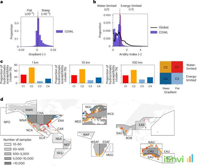
The study’s dataset of approximately 480,000 coastal groundwater monitoring wells represents an unprecedented spatial and temporal coverage of coastal aquifer behaviour. The research period ran from 1990 to 2024, giving the team 34 years of observational data from which to extract trend signals. The threshold used for a statistically detectable trend was a groundwater level change of at least 0.1 metres per year. At that rate, a coastal aquifer could experience a water table decline of 3.4 metres over the full study period, a magnitude more than sufficient to substantially alter the freshwater-saltwater interface in shallow to mid-depth aquifer systems.
One of the most significant findings from a temporal perspective is that groundwater declines have become significantly more frequent since 2016. This nine-year acceleration window is critical because it suggests that the stressors driving decline, primarily over-abstraction compounded by climate-altered recharge patterns and accelerating sea-level rise, are not operating at a steady historical rate but are intensifying. For practitioners constructing predictive hydrogeological models, this non-linear acceleration means that linear extrapolations from historical data will systematically underestimate future risk. The study’s findings challenge steady-state modelling assumptions that remain common in environmental impact assessments and site-specific risk assessments for coastal developments.
The research also found that groundwater changes are most pronounced in two specific settings: deeper water tables and arid environments. Southern Australia satisfies both conditions across large parts of its coastal zone. The southern coastline from the Eyre Peninsula through to the Limestone Coast in South Australia, the Swan Coastal Plain in Western Australia, and parts of coastal Victoria all exhibit combinations of semi-arid to arid climatic conditions and deep, often confined or semi-confined aquifer systems. These hydrogeological characteristics mean that once salinisation penetrates these systems, the natural flushing capacity is severely limited and recovery timescales can extend to decades or centuries. The authors describe this as creating conditions for rapid and potentially irreversible salinisation if abstraction is not tightly managed.
From a contaminated land perspective, the salinity changes documented in this study have direct implications for contaminant behaviour. Increased groundwater salinity can mobilise heavy metals through ionic exchange processes on soil and aquifer matrix surfaces, altering the partitioning of metals such as arsenic, lead, and cadmium between the dissolved and sorbed phases. Salinity shifts also alter the microbial communities responsible for natural attenuation of organic contaminants including petroleum hydrocarbons and chlorinated solvents, potentially slowing or redirecting degradation pathways. These are not speculative concerns. They are well-documented geochemical and microbiological responses to salinity transitions that practitioners must account for when maintaining and updating site conceptual models in coastal zones.

Australian context: seawater intrusion risk under national and state regulatory frameworks
Australia’s regulatory frameworks for groundwater management and contaminated land assessment were largely developed during a period when coastal aquifer conditions were treated as relatively stable background conditions. The National Environment Protection (Assessment of Site Contamination) Measure 1999 (as amended 2013)
References and related sources
- Primary source: www.nature.com
How iEnvi can help
iEnvi provides specialist consulting services relevant to this topic. Our team includes CEnvP Site Contamination Specialists with experience across contaminated land, groundwater, remediation, ecology, and regulatory compliance.
- iEnvi contaminated land services
- iEnvi remediation services
- iEnvi expert services and independent review services
This is an iEnvi Machete news summary. Prepared by iEnvi to summarise the source article for contaminated land, groundwater, remediation, approvals and site risk professionals.
Published: 19 Apr 2026
Need advice on this topic? Speak to an iEnvi expert at info@ienvi.com.au or 1300 043 684, or contact us online.
Need advice on this issue? iEnvi provides practical, senior-led environmental consulting across contaminated land, remediation, ecology and environmental risk.
Team credentials Contaminated land services Remediation services Groundwater services Talk to iEnvi