
Alice Springs Water Allocation Plan 2026-2036: What Has Changed
The Northern Territory Government has declared the Alice Springs Water Allocation Plan 2026-2036, a ten-year statutory instrument that resets how groundwater is managed across the Alice Springs Water Control District. Minister for Lands, Planning and Environment and Minister for Water Resources Joshua Burgoyne signed off on the plan on 5 August 2026, bringing into force a new regulatory framework covering 4,528 square kilometres of Central Australia.
For environmental professionals this is not a minor administrative update. The plan replaces twelve previous management zones with five consolidated groundwater management zones and sets a hard cap on extraction volumes across the entire system. Anyone advising on land development, water licensing, mining logistics, or contaminated site assessment in the Alice Springs region now needs to work against a materially different regulatory map than existed before August 2026.
The stakes are elevated because the primary aquifer covered by the plan, the Mereenie Aquifer System, is the sole source of public drinking water for Alice Springs. Any groundwater extraction, contamination event, or land use change that could affect that resource will attract a level of regulatory scrutiny that consultants working from the old 12-zone framework are unlikely to have anticipated.
New Groundwater Zones, Extraction Limits and the Mereenie Aquifer System
The Alice Springs Water Allocation Plan 2026-2036 is made under the Water Act 1992 (NT) and operates as a binding statutory instrument for the full ten-year period. It sets an Estimated Sustainable Yield of 24,670 megalitres per year across the water control district, a figure derived from 70 years of hydrogeological monitoring and modelling data. This ESY functions as the ceiling against which all extraction entitlements, licence renewals, and trading arrangements will be assessed for the life of the plan.
The consolidation from twelve zones to five is the most significant structural change for practitioners. The new zones are Town, Inner Farm, Outer Farm, Wanngardi, and Mereenie. Each zone carries its own sub-allocation and monitoring regime, but they now sit within a simplified administrative boundary set that is intended to make cumulative extraction easier to track and easier to enforce. Previous zone boundaries used in existing conceptual site models, licence conditions, and groundwater trading records will need to be cross-referenced against the new five-zone geometry rather than assumed to carry over unchanged.
The Mereenie Aquifer System receives particular attention in the plan because it underlies the public drinking water supply for Alice Springs. Extraction and monitoring settings for this zone are explicitly designed around protecting that supply, which means any proposed extraction, dewatering activity, or contamination pathway intersecting the Mereenie zone should expect a higher bar for approval and ongoing compliance reporting than in the other four zones.
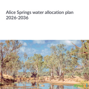
The plan also incorporates protection settings for surface water-dependent ecological assets, with river red gum communities specifically identified as a value requiring safeguarding under the risk-based adaptive management approach embedded in the document. Aquatic ecosystem protection continues to be assessed against the Australian and New Zealand Guidelines for Fresh and Marine Water Quality (ANZG 2018), which remains the default national reference for groundwater-dependent ecosystem values in the absence of NT-specific numeric criteria for these assets.
How NT Water Allocation Plans Compare with Other Australian Frameworks
Water allocation plans of this type sit within a broader national trend toward consolidated, evidence-based groundwater management frameworks, but the Northern Territory approach has its own statutory character under the Water Act 1992 (NT) rather than the water sharing plan mechanisms used in NSW or the sustainable diversion limit framework under the Murray-Darling Basin Plan. Practitioners moving between jurisdictions need to recognise that NT allocation plans function as direct statutory instruments governing licensing decisions, not advisory documents that inform separate approval processes.
For contaminated land practitioners, the plan’s relevance connects most directly to groundwater risk assessment methodology rather than to soil contamination frameworks such as the NEPM 2013 Health Investigation Levels or the PFAS NEMP. Where a site investigation in the Alice Springs district involves groundwater as a potential migration pathway or receptor, the extraction limits and zone boundaries in the new plan become part of the conceptual site model, particularly where a plume or dewatering activity could interact with an aquifer that also supplies drinking water.
The explicit reference to ANZG (2018) guidelines for protecting groundwater-dependent ecological assets like river red gums reinforces that ecological receptor identification in Central Australian groundwater assessments should be treated with the same rigour applied to surface water assessments elsewhere in Australia. Consultants accustomed to working in coastal or riverine catchments where ANZG trigger values are well established for aquatic fauna should expect similar expectations applied to arid zone groundwater-dependent vegetation communities under this plan.

What Consultants, Developers and Licence Holders Need to Do Now
Any hydrogeologist or contaminated land consultant with an active project in the Alice Springs Water Control District should immediately compare existing conceptual site models against the new five-zone boundaries. Zone reclassification could change which extraction limits, monitoring obligations, or licence conditions apply to a site, even where the physical location of the investigation has not changed. This is a document review task that should occur before any further field work, sampling design, or reporting is finalised on an active project.
Developers and proponents planning new projects in the district should factor the 24,670 megalitre per year Estimated Sustainable Yield into feasibility assessments from the outset. With a hard cap now in place across the entire system, the availability of new extraction entitlements will depend on the remaining headroom within each zone’s sub-allocation, and projects relying on groundwater in or near the Mereenie zone should budget for a longer approval pathway and more demanding compliance conditions. Existing licence holders should also review renewal timelines against the new plan, as renewals will be assessed against the 2026-2036 framework rather than the settings that applied when the original licence was granted.
References and related sources
- Primary source: nt.gov.au
- miragenews.com
- nt.gov.au
- nt.gov.au
- nt.gov.au
- ANZG Water Quality Guidelines
- Australian Drinking Water Guidelines
How iEnvi can help
iEnvi provides specialist consulting services relevant to this topic. Our team includes CEnvP Site Contamination Specialists with experience across contaminated land, groundwater, remediation, ecology, and regulatory compliance.
- iEnvi contaminated land services
- iEnvi remediation and validation services
- iEnvi expert services and independent review services
This is an iEnvi Machete news summary. Prepared by iEnvi to summarise the source article for contaminated land, groundwater, remediation, approvals and site risk professionals.
Published: 08 Aug 2026
Need advice on this topic? Speak to an iEnvi expert at info@ienvi.com.au or 1300 043 684, or contact us online.
Need advice on this issue? iEnvi provides practical, senior-led environmental consulting across contaminated land, remediation, ecology and environmental risk.
Team credentials Contaminated land advice Remediation services Groundwater services Talk to iEnvi