Overview
On 22 April 2026, researchers from the University of California, San Diego, and UCLA published a new method in Nature Geoscience. The paper introduces GOFLOW (Geostationary Ocean Flow), an artificial intelligence model that extracts high-resolution ocean surface current data from thermal infrared imagery captured by existing geostationary weather satellites. The finding is notable precisely because it requires no new spaceborne hardware: it repurposes orbital assets already in continuous operation, such as the GOES-East satellite, to generate oceanographic intelligence that was previously considered unattainable through passive remote sensing alone.
Until now, resolving the small-scale, fast-moving turbulent current structures that govern the transport of heat, nutrients, and pollutants across ocean surfaces required either costly dedicated oceanographic satellites, expensive in-situ sensor deployments, or both. GOFLOW addresses this limitation by applying machine learning to identify temperature gradient structures within thermal infrared imagery and correlating those structures with the underlying current dynamics. The result is a continuous, cost-effective stream of high-fidelity spatial data covering the ocean surface at scales previously out of reach for routine monitoring programmes.
For environmental professionals working across climate risk assessment, marine pollution modelling, fisheries management, and coastal infrastructure planning, this development is directly relevant. The ability to track small-scale, fast-moving currents with greater accuracy fundamentally improves the inputs available for hydrodynamic models, pollutant transport analysis, and ecological risk assessments. As AI-driven remote sensing tools mature and move toward integration in standard practice, understanding the methodological basis and practical limits of GOFLOW will be important for practitioners advising developers, regulators, and coastal asset owners.
Key details of the GOFLOW methodology and findings
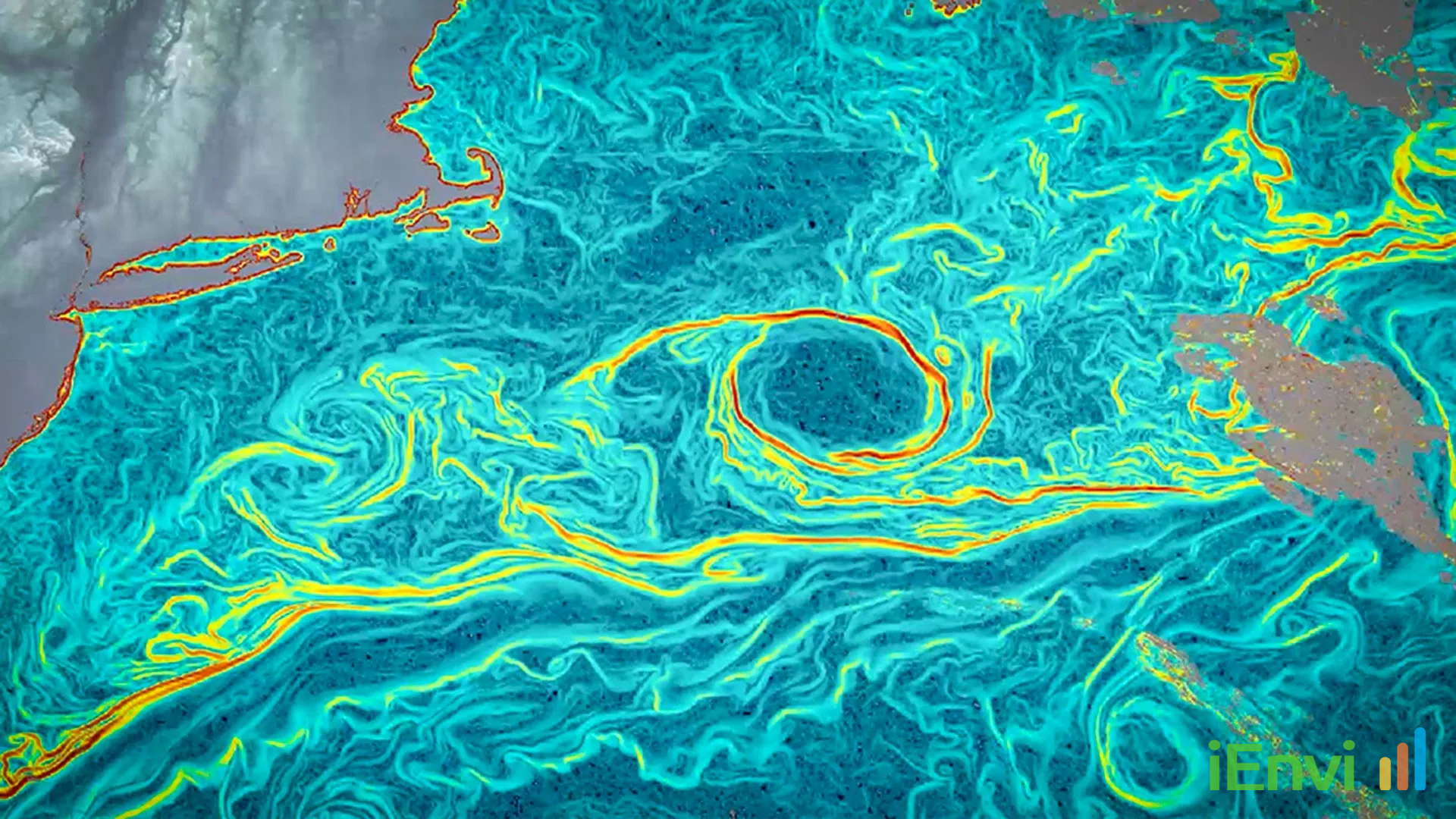
GOFLOW processes thermal infrared imagery from geostationary weather satellites, with GOES-East serving as the primary platform referenced in the research. Geostationary satellites occupy fixed orbital positions approximately 35,786 kilometres above the Earth’s equator, which allows them to image the same ocean surface area repeatedly and at high temporal frequency. This temporal density is precisely what GOFLOW exploits: by analysing sequences of thermal infrared frames, the AI model identifies how temperature gradient structures shift over time and uses those shifts as tracers for the motion of surface water masses.
The core methodological insight is that ocean surface temperature patterns, while not themselves directly measuring current velocity, contain embedded information about the dynamics of the water column immediately below. Warm and cold water bodies moving past one another generate thermal fronts, filaments, and eddies that are detectable in infrared imagery. GOFLOW’s AI architecture is trained to decode these structures and reconstruct the underlying current field with a spatial and temporal resolution that exceeds what was previously achievable through satellite-based methods. The published findings demonstrate that the model can resolve turbulent motions and fast-moving currents that conventional broad-scale satellite oceanography has historically struggled to capture.
A critical practical attribute of the method is its reliance on existing orbital infrastructure. Weather satellites such as GOES-East are operated for meteorological purposes and their imagery is already collected continuously at no additional mission cost. By extracting oceanographic value from this pre-existing data stream, GOFLOW substantially lowers the barrier to entry for large-scale, continuous ocean current monitoring. This efficiency advantage means that institutions and agencies with access to archived or real-time geostationary imagery can, in principle, apply the GOFLOW approach to retrospective analysis as well as ongoing monitoring, without commissioning dedicated satellite passes or deploying arrays of ocean buoys.
The research identifies a specific capability gap that GOFLOW addresses: the disconnect between broad-scale satellite observation, which captures large circulation patterns such as major boundary currents, and the difficult-to-observe, small-scale turbulent motions that are critical for accurate ecological and climate modelling. It is precisely these small-scale structures, including submesoscale eddies, coastal upwelling filaments, and tidal mixing zones, that control the local transport of dissolved substances, particulate matter, and biological organisms. Prior to this development, modellers have had to either parameterise these processes coarsely or rely on expensive targeted data collection campaigns to constrain their simulations.

Australian context: relevance to marine monitoring, contamination assessment, and coastal regulation
Australia’s marine estate is one of the largest in the world, encompassing approximately 8.2 million square kilometres of ocean under Commonwealth jurisdiction, in addition to extensive state marine waters. The monitoring of pollutant transport, sediment dynamics, and ecological health across this estate has long been constrained by the difficulty and cost of obtaining fine-resolution current data at ecologically meaningful scales. Australian regulators and practitioners work within a framework that includes the Australian and New Zealand Guidelines for Fresh and Marine Water Quality (ANZG 2018), the National Environment Protection (Assessment of Site Contamination) Measure 2013 (NEPM 2013) for terrestrial contamination matters, and state-based marine pollution and coastal management legislation such as the Protection of the Environment Operations Act 1997 (NSW).
References and related sources
- Primary source: www.sciencedaily.com
- kersai.com
- ienvi.com.au
- bostoninstituteofanalytics.org
- coaio.com
How iEnvi can help
iEnvi integrates technology and data-driven approaches into environmental consulting. We monitor AI and technology developments that affect how environmental professionals deliver services to clients.
This is an iEnvi Machete news summary. Prepared by iEnvi to summarise the source article for contaminated land, groundwater, remediation, approvals and site risk professionals.
Published: 23 Apr 2026
Need advice on this topic? Speak to an iEnvi expert at hello@ienvi.com.au or 1300 043 684, or contact us online.
Need advice on this issue? iEnvi provides practical, senior-led environmental consulting across contaminated land, remediation, ecology and environmental risk.
Contaminated land services Remediation services Groundwater services Ecological assessment Talk to iEnvi